MERLE’S CORNER
When Peggy Krauch and I visited Gallery 200 at 103 W. Washington St. to see the exhibit of Marita Valdizan Friday, June 6, 2025, it was a hive of activity. The many people attending were there either to see the exhibit or to attend the school art class. Conversations were buzzing about the artwork, the Gallery and the other exhibits in the building, Japanese art and Mexican Cultural Center art. The artists and the guests were thoroughly enjoying the evening. It makes one realize what a perfect facility it is to showcase the many artists and art events in the community, and how fortunate we are to have.it. Gallery hours at 103 W. Washington St. are noon to 6 p.m. Wednesday and Thursday, from 10 a.m. to 6 p.m. Friday, from 10 a.m. to 4 p.m. Saturday, from noon to 4 p.m. Sunday and closed Monday and Tuesday.
AROUND AND ABOUT
- The West Chicago Public Library hosts a family-friendly event, “Cruisin’ Thru the Afternoon,” from 1 to 3 p.m. Saturday, June 14, 2025, on the lawn and in the parking lot, 118 W. Washington St. Several local auto clubs bring some of their show cars to exhibit. Chevrolet of Naperville brings some of its new model automobiles; attendees can vote for their favorite car. The winner of the votes receives a commemorative trophy. Also, persons of any age can enter a competitive race with Remote Control cars. Youths can make their own wooden car craft; there is an obstacle course for toddlers based on Pixar’s Cars. Complimentary snow-cones and popcorn are available. Also, there is a drawing of fun road-themed prizes; visit the library table to enter. To accommodate this event, part of the library’s parking lot will be closed. The book drop near Turner Court is inaccessible until 5 p.m. Patrons can find additional parking in the triangular parking lot near the entrance of Turner Court.
- West Chicago Park District holds a Family Fishing Derby from 8 a.m. to noon Saturday, June 14, 2025, at Cornerstone Lakes Park, 2199 Smith Road. Winners in each age category receive a trophy. Age categories are 3 to 5 years, 6 to 8 years, 9 to 12 years, 13 to 18 years, and 18 and over. Catch and release is practiced. The charge is $10 for residents, $12 for non-residents, and $15 for walkups, which includes a light breakfast, and a goodies bag. Persons can register online at https://www.we-goparks.org/special-events or on the day of the event. This is a great time to have some fun while checking out one’s fishing equipment and favorite bait. https://merleburl.com
- West Chicago Public Library offers a Microsoft Excel computer class at 12:30 p.m. Wednesday, June 18, 2025, in the conference room, 118 W. Washington St. Topics covered include layout and basic functions; entering and editing data; using multiple spreadsheets in the same workbook; formatting and sorting data; writing and understanding formulas. To register, visit https://wcpld.librarycalendar.com/events/month/.
- West Chicago City Museum presents the Historiography program, a non-fiction book reading group, at 1 p.m. Thursday, June 19, 2025, in the Museum, 132 Main St. The book is “Lifting as They Climbed: Mapping a History of Trailblazing Black Women in Chicago” by Marianne Kaba and Essence McDowell. To get a copy of the book or for further information, visit Friends of West Chicago City Museum website, https://wegohistory.com or call 630 231-3376. It is not necessary to read the book to attend.
Haymarket Books said, “An essential guidebook to influential Black women from Chicago’s South and West Sides, and their social, cultural, and artistic contributions to movements both past and present…It gives readers an in-depth understanding of the numerous Black women, from the nineteenth century to today, who empower(ed) their neighborhoods and communities.” The book showcases 75 women who are/were activists, artisans, and musicians.
Essence McDowell is a writer, communications strategist and creative director. She utilizes community engagement, digital design, and communication technologies to strengthen community institutions, and advance justice-based organizations. She has worked with national and local entities: Illinois Humanities Council, Chicago Torture Justice Memorials, Latino Policy Form, Black Feminist Future, and Chicago Public Schools. Mariame Kaba is an organizer, educator and curator, who is active in numerous social movements for prison abolition, racial justice, gender justice, and transformative justice. She is the founder and director of Project NIA, a grassroots organization with a vision to end youth incarceration, and a co-founder of numerous organizations, including the Chicago Freedom School, Love and Protect, the Chicago Taskforce on Violence against Girls and Young Women and most recently Survived & Punished. https://merleburl.com
- “History of Motown Records” is the West Chicago Public Library program starting at 7 p.m. Thursday, June 19, 2025, in the main meeting room, 118 W. Washington St. Presenting the program is music historian and award-winning lecturer, Gary Wenstrup, who uses audio and video content to tell the story. To register, visit https://wcpld.librarycalendar.com/events/month. In the 1960’s in Detroit, Motown Records produced hits sung by performers such as The Supremes, The Temptations, Marvin Gaye and Stevie Wonder. Upon retirement, Gary Wenstrup developed courses on the Beatles, Simon & Garfunkel and Motown Records for the Continuing Education Department at College of DuPage. Gary has lectured at more than 200 libraries across the country. https://merleburl.com
- The West Chicago Park District offers Parents Night Out from 6 to 9 p.m. Friday, June 20, 2025, in the ARC, 201 W. National St. Parents drop off their children who are between the ages of three and 10, and then enjoy an evening together. Activities for the children include pizza dinner, games and crafts, plus staff-supervised free-play in the Tree Top Escape and gym. The charge is $15 per child for residents and $18 per child for non-residents. To make a reservation, visit we-goparks.org/youth-programs.
- The Shopping Cart Shuffle takes place Saturday, June 21, 2025, at Ross Ferraro Town Center in Carol Stream. The proceeds from the race benefit Neighborhood Food Pantries, which includes the one in West Chicago located at 123 Fremont St. Registration is at 7:30 a.m. The Kids Dash is at 8:15 a.m. and the 5K race is at 8:30 a.m. All participants receive the same event t-shirt, finisher medal and other items. The top three overall male and female runners receive a medal, as do the top runners in each age category. Age groups are 13 and under, 14 to19, 20 to 29, 30 to 39, 40 to 49, 50 to 59, 60 to 69 and 70 and over. The cost is $40 for the 5K Run and 2K Walk; Kid’s 100 Yard Dash is free, no shirt. Persons can register online at https://www.neighborhoodfp.org/event. Since 1999, Neighborhood Food Pantries has provided food security to neighbors in need, as well as monetary assistance for housing, utilities and medical care/prescriptions. For further information, call Elizabeth Zrelak at 630-945 0072. Jel Sert Company is one of the sponsors. https://merleburl.com
- West Chicago Park District hosts Hello Summer Fest from 11 a.m.to 3 p.m. Saturday, June 21, 2025, at Reed-Keppler Park, 129 W. National St. The family event includes the fun of bounce houses and games. Off the Chart band provides the musical entertainment. When favorite songs played on the radio, they were always on the top 40 or top 100 charts. This band covers songs no longer on the charts with songs of rock, country, folk and more.
- The West Chicago Public Library Gettin’ Crafty program, “Nautical Vases” is at 7 p.m. Wednesday, June 25, 2025, in the main meeting room, 118 W. Washington St. To register, visit https://wcpld.librarycalendar.com/events/month. Attendees repurpose a plastic bottle into a cute nautical-themed vase; All supplies are included.
- West Chicago Railroad Days takes place from Thursday, June 26, through Sunday, June 29, 2025, at Pioneer Park, 479 W. Forest Ave. The Western DuPage Chamber of Commerce is accepting applications for exhibitor vendors, food vendors and not-for-profit vendors. For vendor application and more fest information, visit https://www.westchicagorailroaddays.com/. Independence Day fireworks take place at dusk Saturday, June 28. https://merleburl.com
SUPPORT OUR LOCAL BUSINESSES
- Sonny Acres Farm, 29W310 North Ave., hosts its Third Annual Pro Rodeo and Bull Riding event. It takes place Friday, June 13, Saturday, June 14, and the following weekend of Friday, June 20, Saturday, June 21, and Sunday, June 22, 2025. Gates open at 4:30 p.m.; show begins at 6:30 p.m. To order tickets and for more information, visit https://sonnyacres.com/pro-rodeo-at-sonny-acres-farm/. It is a family friendly experience for all ages. There is a mix of world class performances including Bareback Riding, Steer Wrestling, Saddle Bronc Riding, Girls Breakaway Roping, Cowgirls Barrel Racing and Bull Riding. Spotlight performance is by world-renowned Trick Rider and Roman Rider, Dusti Crain Dickerson, and includes her signature fire jump. Also available are the farm’s amusement rides, live musical entertainment, pony rides, petting zoo, kitchen & grill, garden center, and shops. https://merleburl.com
- Jel Sert Company held a ribbon cutting for the opening of its new production facility at 444 Charles Court on Thursday, June 5, 2025. In addition to the hiring of more than 100 new employees, the renovated 75,000 square feet of the existing distribution facility now houses additional production lines. It is expected to bring the total workforce at Jel Sert to 1,400, which is now nearly 1,000. The company received an Economic Development for a Growing Economy, or EDGE, tax credit from the state as part of its investment.
Among the speakers at the event were Governor JB Pritzker and State Senator Karina Villa. The Governor said, “Beginning as a small operation nearly 100 years ago, Jel Sert has grown into a global powerhouse, with its home base right here in Illinois. This $10 million investment will help meet booming consumer demand for Jel Sert's products, and in the process, create more manufacturing and packing operations jobs for Illinoisans.” Afterwards, Villa said, “As a lifelong resident of West Chicago, I have witnessed families over the years obtain employment opportunities through Jel Sert, who have been able to establish strong leadership and rapport with employees which has only contributed to its success.” Others attending included State Representative Maura Hirschauer, DuPage County Board Chairman Deborah Conroy, District 6 County Board members Greg Schwartz and Sheila Rutledge, who also is Winfield Township Supervisor, Mayor Daniel Bovey and Ward 1 Alderman Julieta Alcantar-Garcia.
As a side note: There is a picture of Dave Sabathne, CEO/President Western DuPage Chamber of Commerce, with Ken Wegner, President of Jel Sert, and Chuck Wegner, Board Chairman of Jel Sert. Not certain what was the coolest part of the photograph, Sabathne said, “The fact that we have the same picture 24-years ago at the groundbreaking for this facility or the fact the Governor of Illinois was the photographer. When he heard Chuck say, ‘We have the same picture from 24-years ago,’ Governor Pritzker said ‘Well, we definitely have to get this one too.’ and took the phone out of my hand and snapped a great shot.” https://merleburl.com
- Several West Chicago businesses were picked in the 2025 Daily Herald’s Readers’ Choice. St. Andrews Golf & Country Club was picked for Best Venue for a Quinceañera, Best Driving Range and Best Public Golf Course. Best School District choice was St. Charles Community Unit School District 303. College of DuPage was a choice for Best Community College. Ace Hardware and Menards at multiple locations were picked for Best Hardware/Home Improvement Store.
REMEMBRANCES
- Sincere sympathy is extended to the family of Alan G. Foster, who at the age of 92 passed away Tuesday, May 27, 2025.
- Deepest sympathy is expressed to the family of Gloria Vicens-Ocotoxtle, who at the age of 52, passed away Saturday, June 7, 2025.
- Sincere sympathy is extended to the family of Dorothy Raye Jackson, who at the age of 83 passed away Saturday, June 7, 2025.
- Deepest sympathy is expressed to the family of C. William (“Bill”) Pollard, Jr. who at the age of 87, passed away Friday, June 6, 2025.
SCHOOLS
- Through Community High School District 94, there are free summer meals for all youths under the age of 19 Mondays through Fridays, through Aug.1, 2025. The hours and locations are from 10 a.m. to noon at West Chicago Community High School, 326 Joliet St., door 25; from noon to 2 p.m. at Timber Lake Apartments, 1200 Kings Circle, near the pool; and from noon to 2 p.m. at Reed-Keppler Park, National Avenue and Yale Street. The youths eat the meals on-site.
- West Chicago Community High School’s Business Professionals of America chapter proudly represented Illinois at the 2025 National Leadership Conference in Orlando, Florida. The students competed against thousands of top qualifiers from across the country.
The seven minute presentation by seniors Brian Nguyen, Ryan Slattery, Dirk Ulbrich, and Benjamin Plumlee focused on "Explaining the primary objectives of monetary policy and the tools central banks use to achieve these goals.” They earned an outstanding 16th place finish out of 384 teams nationwide.
Daniel Szacilowski showcased his technical skills in two national events, Device Configuration and Troubleshooting, and Advanced Spreadsheet Application. In the first one, his score placed him 30th out of 100 students nationally, and he earned a Certiport IT Specialist Certification in Device Configuration and Management. He scored 43rd out of hundreds of competitors.
Manny Figueroa competed in Digital Media Production, creating a compelling a one to two minute public service announcement, focused on topics such as anti-bullying, mental health awareness, or environmental issues.
Brian Nguyen entered an individual open event, Financial Math and Analysis Concepts. He earned 19th place out of 313 students nationwide.
Aidan Ryan, Illinois Executive Board Historian and Chapter President, played an essential role in both the planning and facilitation of the State Leadership Conference and contributed to activities at the National level. https://merleburl.com
- Wheaton Academy students Kellen Sauer, Joel Baarman and Micah Wilding were named Volleyball All Conference in the 2025 Christian Conference. The Boys Volleyball team were Co-Champions in the conference. https://merleburl.com
- As the 2024/2025 school year winds down in West Chicago Elementary School District 33, it is also the end for some faculty and staff. The recognition took place Thursday, June 5, 2025, at Hawthorne’s Backyard Bar & Grill.
Retiring are Suzan Avila, fifth grade teacher, 31 years; Eric Godoy, orchestra teacher, 32 years; Tracey Laws, Math interventionist, 34 years; Graciela Moreno, guidance counselor, 11 years; Kathleen Sawick, alternative education teacher, 33 years; Jesus Serna, social worker, 30 years; Gina Steinbrecher, Assistant Director of Communications & Marketing, 17 years; Ilona Truckenbrod, literacy and numeracy resource, 5 years; Lori Waldschmidt, ELS paraprofessional, 26 years; and Marybeth Zarndt, physical education teacher, 34 years. In his nine years with the district, Mark Truckenbrod has worn several hats. He was principal of Currier School, interim principal at Wegner and Turner Schools, and Director of Human Resources.
Celebrating their 20-year milestone in the District are Janet Ayala, instructional coach; Rebecca Hall, GATE teacher; Lisa Jirovec, third grade teacher; Lori Koch, guidance counselor; Patricia Macko, ELC teacher; Connie McCleery, lunchroom supervisor; Robert Rising, computer teacher; Jacqueleen Robinson, ESL paraprofessional; Silvia Snell, ESL paraprofessional; and Cree Sochor-Clegg, ESL paraprofessional.
Celebrating their 25-year milestone are Humberto Benitez, custodian; Martha Boers, ESL paraprofessional; Rosemary Campos-Arroyo, dual language teacher; Myrna Carrera Urbina, second grade teacher; Amie Correa, Gary School principal; Marie Frohnauer, fourth grade teacher; Aura Martinez, ESL paraprofessional; Brian Miller, physical education teacher; Norma Miranda, lunchroom supervisor; and Leticia Valdivia, social worker.
Celebrating their 30-year milestone are Karen Apostoli, Director of Business and Operations; Angelica Porcayo, student supervisor; and Jesus Serna, social worker. https://merleburl.com
- The St. Charles East High School Softball team is the 2025 Regional Champion and now also is the Sectional Champion. This is in the Illinois High School Association AA class. https://merleburl.com
- Wheaton Academy Lacrosse team placed third in the Illinois High School Association state finals. The team had a 19-4 win over Nequa Valley High School. It was their fourth time at state finals in five years and the third time placing third. https://merleburl.com
- The class of Archana Shukla at Leman Middle School hosts a weekly coffee delivery service called Charger's Cafe. Throughout the year her students saved all the coins they received and turned it into a math lesson. They counted the money, separated all the coins and rolled them up. Monday, June 9, 2025, they presented the money as a donation to Special Olympics Illinois to West Chicago Police Sergeant Detective Robbi Peterson https://merleburl.com
- Nick Roskilly won fifth place in high jump at the Illinois High School Association State Meet. He is the first high jump qualifier since 2011. https://merleburl.com
- Judah McLean, Jasmyn Trigueros and Robert Lee are 2025 Athletes of the Year. All three athletes have been dedicated to multiple sports throughout their 4 years at WeGo. McLean was involved in cross country and track and field. Trigueros was involved in volleyball, basketball and softball. Lee was involved in football, basketball and track and field. https://merleburl.com
- The 2025 All-Conference badminton individuals are Michaela Miller, Hadassah Ramirez, Alina Ortiz, Arely Angeles, Yazmin Castro Mora, Noelia Vargas and Cristal Salinas. https://merleburl.com
- The 2025 Baseball All-Conference recipient is Sam Zalak. https://merleburl.com
- The 2025 All-Conference softball individuals are Jasmyn Trigueros, Finn Gallagher, Brielle Borner, Sophia Peak and Tessa Banasiak. Trigueros is Player of the Year for the east division. She had 450 strikeouts in her softball career at the high school.
- The 2025 All-Conference volleyball individuals are Joe Trigueros, Vincent Spadoni and Phillip Cabrera. Spadoni is Player of the Year. https://merleburl.com
- The 2025 Girls Track All-Conference individuals are Leah Ashland and Jessica Balmer. The 2025 Boys All-Conference individuals are Judah McLean, Robert Lee, Romeo Alfaro, Daniel Duran, Nicholas Roskilly, Noah Case, Joe Kurby, Andre Dzwiniel and Daniel Szacilowski. https://merleburl.com
- Starting with its Monday June 9, 2025, meeting, all Benjamin School District 25 Board of Education meetings are now live-streamed, recorded and posted to the district website, https://www.bendist25.org/. To access the live-stream link directly visit https://youtube.com/@benjaminsd25boardmeeting?feature=shared.
CHURCHES
- United Women in Faith at New Hope United Methodist Church hold its annual “My Trash—Your Treasure” rummage sale from 5 to 7:30 p.m. Friday, June 13, and from 9 a.m. to noon Saturday, June 14, 2025, at the church building, 643 E. Washington St. The popular “bag” special applies to clothing and linens. The charge for a filled paper bag is $5 and $10 for a tall white plastic kitchen garbage bag. All other items are on a “make an offer” basis.
- West Chicago Community Clothing Closet, operated by St. Michael’s United Church of Christ, is open from 9 a.m. to noon Saturday, June 14, 2025, in the basement of the Rockwell Building, 108 Sherman St. There is no charge for the clothing and shoes. Each family may choose five articles of clothing per person in their family. The Closet is open the second Saturday of each month. Bagged or boxed clothing donations can be dropped off at the entrance of the Rockwell Building.
- Andrew Lutheran Church, 155 N. Prince Crossing Road, hosts Everyday Hero, a program of DuPage Health Coalition, from 10 a.m. to noon, Saturday, June 14, 2025. Participants learn CPR, AED, and Narcan Training. The class is in English and Spanish. The free training includes basic life support skills, practice hands-only CPR, how to use an automated defibrillator, and Narcan and overdose education. To make a reservation call Pastor Alex modern at 847 912-2029 or email pastoralex@st.andrewlutheranlutheran.net.
- Faith Community Church, 910 Main St., hosts its Second Annual Community Celebration from 11 a.m. to 3 p.m. Saturday, June 14, 2025. The event, open all in the community, offers a summertime of fun activities such as free food from Toasty Cheese, Sugar Mama's Mini Donuts and La Humita on Wheels food trucks, inflatables, yard games, face painting and, possibly, a dunk of the pastor in a pool. Live entertainment by Front Row Band, who play songs from the 60s through the 80s, is at 12:30 p.m. Dave Wright, the church music director, is in the band. There is a mini Touch-A-Truck with West Chicago Fire Protection District and West Chicago Police Department K9 unit. Attendees can also bring a non-perishable food item for Neighborhood Food Pantries at 123 Fremont St. Persons attending need to use the Hillview entrance.
- Trinity Lutheran Church, 328 George St., hosts a “meet and greet” for the new pastor, Reverend Eric Mueller, and his family following the 9:30 a.m. worship service Sunday, June 15, 2025, in the Fellowship Hall. Pastor Fred Gaede retires the end of June. https://merleburl.com
COMMUNITY MEMBERS HIGHLIGHTS
- West Chicago resident Mike Hensel does a reading and book signing of his book, “Unicorn, Go To Bed,” at 1 p.m. Saturday, June 14, 2025, (Note Date Correction) in Harvey’s Book Store, 216 James St. in Geneva. The book, geared for three to 6 year old, has a five-star rating on Amazon. “Silly, colorful illustrations and engaging rhyming text bring this all-too-familiar bedtime tale to life, as each exasperated plea to go to bed is met with a seemingly innocent last request for a snack or a favorite stuffy, which inevitably spirals out of control.”
Mike Hensel is the son of the late David and Linda Hensel, and the nephew and godson of West Chicago resident Dona Smith. The owners of the bookstore, Chuck and Roxanne Osborne, also have a connection with West Chicago. Chuck was a science teacher at West Chicago Middle School, now Leman Middle School. He retired in 2018.
- Former West Chicago resident and member of New Hope Methodist Church, Greg Watts, won the North Carolina Hot Sauce Contest and Festival. Before moving out of state, Greg and his wife Wendy sold their hot sauces at the Winfield Farmers Market. https://merleburl.com
CLUB/ORGANIZATION NEWS
- American Legion Post 300, 123 Main St., offers $1 wings from 3 to 8 p.m. Wednesdays. Sauces are Buffalo, Sweet chili, Honey hot, Garlic Parmesan, Kick’n Bourbon, Mango habanero and Jamaican jerk. Dry seasonings are Lemon pepper, Nashville hot and Garlic parmesan. Persons have the choice of dine in or carry out. Telephone number is 630 231-2112.
- The weather Sunday, June 1, 2025, was perfect for a birthday party. This was ideal for WeGo Together for Kids, which was celebrating its 20th birthday with a party at Reed-Keppler Park. More than 250 attended. The families participated in the activities, listened to entertainment by different District 33 groups and cast members from the WeGo Community Theater. Past WGTK directors, Joie Frankovich and Sarah Norton, were among the guests. Speakers were WGTK Director Molly Dean, founding Director Marjory Lewe-Brady and out-going Steering Committee Chair Kyle Reschke. Dean said, “The day was so great!” https://merleburl.com
- The rain did not dampen the spirits of golfers, volunteers and sponsors at the Western DuPage Chamber of Commerce 3W Golf Classic Wednesday, June 4, 2025, held at St. Andrew's Golf & Country Club. Although there was some “fore” play, the golfers finished playing the 18 holes and enjoyed the luncheon and awards celebration. First place teams RAC Soto Enterprises (third year in a row). Winning second place was Republic Bank team. The team of Efrain Aguilar, Marvin Boorsooma and Dian Amnos won third place. Other prize winners were Steve Gudon, longest putt from the green; Angela Buton, longest drive for a woman; Mike Noa, longest drive for a man; Jacob Buchholz, straightest drive; and John Churillo, closest to the pin. Title Sponsors were Buck Services, Inc., Earthwerks, Inc., Tony Reyes Family Foundations, & Lamp Inc. https://merleburl.com
- The Children’s Sensory Garden Fundraiser, hosted by West Chicago Parks Foundation, was a fun and amazing afternoon. Guests spent the time visiting, purchasing raffle prize tickets and playing various outside games at Hawthorne’s Backyard Bar & Grill. The true purpose of the fundraiser, raising money for the garden in memory of Melissa Medeiros, came to the forefront when Melissa’s husband, Marc, gave a small talk, causing many persons to tear up. The exact amount of money raised is not known at this time. Park Foundation officers are Acie Boyd, President; Shawn Preuss, Vice President; Omar Espinosa, Treasurer; and Rebecca Holmes, Secretary. Board members are SueEllen Edwards, Fil Guipoco, Sara Witteck, Ben Nelson and Jessie Felix. https://merleburl.com
CITY OF WEST CHICAGO
- The City of West Chicago and West Chicago Cultural Arts Commission host a special Public Art Celebration, “West Chicago: Waves DuPage,” from 4 to 6 p.m. Friday June 13, 2025, in Gallery 200, 103 W. Washington St. It honors the installation of a vibrant new mural by Naperville artist Rich Lo, featuring a stylized ukiyo-e depiction of West Chicago Community High School, which will mark its 100-year anniversary in 2026. Starting at 5 p.m. there are short comments from community and project partners. Refreshments are served.
This artwork is in conjunction with the 2025 exhibition, “Hokusai and Ukiyo-e: The Floating World,” on view at the Cleve Carney Museum of Art through Sunday, September 21, 2025. Each participating DuPage community is highlighted in the Waves of DuPage: Beautiful Cities Public Art Project through a custom mural inspired by traditional Japanese woodblock prints. For further information on the exhibit, visit https://www.theccma.org/waves-of-dupage.
Rich Lo is an accomplished artist and illustrator. As an illustrator, Rich's illustrative work has appeared in various platforms, from packaging and advertisements for national brands to television commercials. As a fine artist, he has created a diverse collection of unique paintings and drawings, including large installations in downtown Chicago. In addition to his work as an illustrator, Lo is also an author and illustrator of eight children's books.
Per the Cleve Carney Museum of Art at College of DuPage website, “The “Hokusai & Ukiyo-e: The Floating World” exhibition authentically brings 17th-century Japan to life through meticulously crafted recreations, immersive experiences, hands-on activities and historical exhibits. The multi-faceted experience centers around the world-class presentation of a 70-piece collection making its U.S. debut, featured as “Museum Galleries – Chiossone Collection” in the exhibition. The collection features 53 paintings and woodblock prints by the masters of ukiyo-e, including original works by Hokusai, Hiroshige and their contemporaries, and 17 handcrafted objects.” For further information on the exhibit, events and activities, visit https://www.theccma.org/. .https://merleburl.com
- Due to moving from West Chicago, Ward 2 Alderman Heather Browns submitted her resignation.
- West Chicago City Museum started a new series, “Museum Monday.” The June 2, 2025, series highlighted the new exhibit, “Rooted in Place: A Living Story of Land, Legacy and Belonging.” For further information on exhibits, visit https://www.facebook.com/FriendsoftheWestChicagoCityMuseum/.
“For almost two centuries, the soil beneath our feet has quietly recorded every hope, risk, and reunion that built West Chicago.” In the 1830s settlers arrived and broke the ground for new farms, schools, and gathering spots. Two decades later, the railroads arrived forming a junction which led to the name Junction, then Turner and finally West Chicago. Immigrants—Irish and English craftsmen, German shopkeepers, Mexican laborers arrived, building neighborhoods, planting faith communities, and layering new traditions. “Through booms and downturns, through wars and celebrations, one constant remained: the land’s invitation to belong and begin again… Rooted in Place” is our attempt to trace that invitation across generations.” It will continue to grow as people share recipes, stories, not only as an exhibit, but also on the website. “The land has always been the main character in West Chicago’s story. Rooted in Place simply turns the spotlight onto its quiet persistence and the people who answered its call. The exhibit is open, evolving, and waiting for your chapter.” https://merleburl.com
WEST CHICAGO POLICE DEPARTMENT
- Due to construction at the West Chicago police station, persons needing assistance use the door to the left of the main entrance. During normal business hours, persons press the outside call button and then enter the station through the door. A member of the records department will be there shortly. After normal business hours, persons enter through that same door and use the phone inside to get in touch with the dispatch center. To assist with the law enforcement needs, an officer will arrive at the station shortly.
- West Chicago Police Department honors the June work anniversaries of its officers. Celebrating 20 years is Officer Jeffrey Moos. Police Chief Colin Fleury celebrates four years. Celebrating three years is Jean Claude Chassagne. https://merleburl.com
- The City of West Chicago honors hardworking employees with the West Chicago Greatest Of All Time (G.O.A.T.). For the second month in a row, a West Chicago police officer, Sergeant Richard Langelan, was the recipient in May. He actually received three nominations with one of his nominator’s saying, “I am proud to nominate Sergeant Langelan for the G.O.A.T. Award. He leads with compassion, always taking the time to listen, support and mentor others. His commitment to his work is clear, and he consistently goes above and beyond. Sergeant Langelan sets the standard for what it means to serve and inspires other to rise to that standard every day.” Receiving the G.O.A.T. award in March was Targeted Response Unit Officer Blake Bertany. https://merleburl.com
WEST CHICAGO FIRE PROTECTION DISTRICT
- One of the most popular events at the Children’s Sensory Garden Fundraiser, organized by West Chicago Parks Foundation, was the competitive volleyball game between the West Chicago Fire Protection District and West Chicago Police Department. Playing hard, both teams rallied and scored points. When the friendly competition ended, the fire district was the winner. It is fun to be in the audience since one loudly cheers for both teams. https://merleburl.com
ODDS AND ENDS
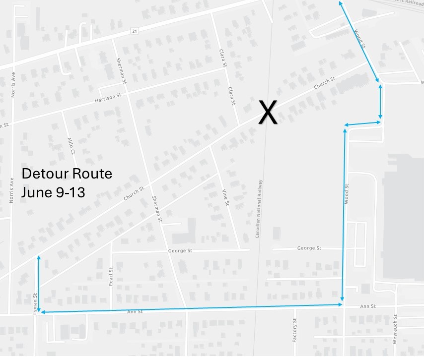
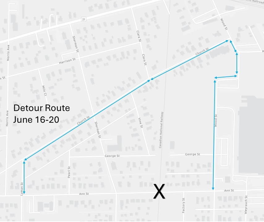
- The Canadian National Railway is making repairs to the railroad crossing on Church Street through Friday, June 13, 2025, weather permitting. The railroad tracks are closed for the duration with a detour plan to direct traffic onto Lyman, Ann, and Wood Streets. Additionally, repairs to the railroad crossing on Ann Street will immediately follow with a schedule anticipated to begin at 9:00 a.m. Monday, June 16, through Friday, June 20, weather permitting. With the closure of the railroad tracks on Ann Street, the same detour route used for the closure of the Church Street tracks will be used with opposite directions.
- Landscape paintings by Douglas Ross are on display at Kindred Roasted Coffee, 148 W. Washington St. Ross is known for his expressionist landscapes. The focus of the majority of his paintings is on the trees, rocks and water that form the dramatic landscape along the north shore of Lake Superior. He started painting after retiring from the University of Nebraska, where he taught sculpture and drawing for 32 years. He passed away at the age of 86 on July 27, 2023. https://merleburl.com
- State Senator Karina Villa once again is sponsoring Books For Scoops. Children reading five or more books during the summer can bring their completed book log from 5:30 to 7:30 p.m. Thursday, August 7, 2025, to Jorge’s Paleteria, 110 S. Neltnor Blvd. They receive a free scoop of ice cream and meet Senator Villa. Book logs are available at West Chicago Public Library, 118 W. Washington St.; Jorge’s Paleteria; or Senator Villa’s West Chicago office, 946 N. Neltnor Blvd, Suite 194. https://merleburl.com
- DuPage County State’s Attorney Bob Berlin announced the formation of his office’s new Animal Protection Unit, which will be comprised of a dedicated team of specially trained assistant state’s attorneys focused on enhancing prosecutions of crimes committed against animals. The press release stated, “Additionally, by recognizing the link between animal abuse and domestic violence, the Unit will also provide further legal protections for citizens who may be at risk of domestic violence.…In addition to prosecuting criminal cases, the Animal Protection Unit will engage in public outreach and education efforts among law enforcement agencies to raise awareness about the importance of responsible pet ownership, animal welfare laws and resources available for those who need assistance with animal care. ”Assigned to the Unit are Assistant State’s Attorneys Nicole English, Alyssa Rabulinski, Anthony Irsuto, and Samantha Musick. The Unit will be supervised by Assistant State’s Attorney Lee Roupas.
- District 6 DuPage County Board Members Jim Zay, Sheila Rutledge, and Greg Schwarze visited the Wayne Township Food Pantry this last week to celebrate the arrival of a shipment of toiletries for needy residents. The County Board provided $10,000 to the pantry to provide the supplies. https://merleburl.com
- The line of cars taking items to the annual Wayne Township Recycling event was long and steady Saturday, June 7, 2025. The volunteers kept the traffic moving smoothly as they helped to unload the items from the vehicles. Township Supervisor Randy Ramey said, “Truckloads of electronics, paper and textiles were kept out of the garbage dumps.” https://merleburl.com
My email address is merleburl@earthlink.net.